

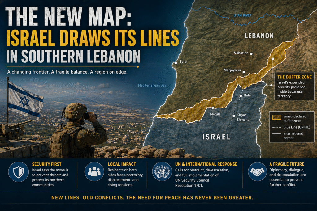
On April 19, 2026, the Israeli military did something unprecedented. It released a detailed map of its new forward deployment line inside southern Lebanon, marking the first time Israel has officially published cartographic documentation of territory under its control beyond its internationally recognized borders .
The map, released just days after a US-brokered ceasefire between Israel and Hezbollah took effect, outlines what Israel calls a “Forward Defense Line”—a buffer zone extending approximately 5 to 10 kilometers deep into Lebanese territory, stretching from the Mediterranean coast all the way to the Mount Hermon area near the Syrian border . This article examines the new map, the territory it claims, and the implications for the region.
Part 1: The Map Released
The Israeli military released the map on Sunday, April 19, via official channels including a post on the IDF’s X (formerly Twitter) account . The accompanying statement explained: “Five divisions, alongside Israeli Navy forces, are operating simultaneously south of the forward defence line in southern Lebanon in order to dismantle Hezbollah terror infrastructure sites and to prevent direct threats to communities in northern Israel” .
The map is notable not only for what it shows but for the timing of its release. The ceasefire between Israel and Hezbollah had taken effect just days earlier, following the first direct talks between the two countries in decades . Yet the map made clear that, for Israel, a ceasefire did not mean a withdrawal.
Part 2: The Territory Defined
The Forward Defense Line runs east to west across southern Lebanon, bringing dozens of mostly abandoned Lebanese villages under Israeli military control . Key locations north of the line include the cities of Bint Jbeil, Aita al-Shaab, and Khiam—towns that saw heavy fighting during the conflict .
The buffer zone is not uniform in depth. In some sectors, it extends as far north as the Litani River, encompassing multiple villages and strategic ridge lines . The total area under Israeli operational control represents a significant military footprint, with multiple divisions deployed alongside naval forces .
Crucially, the map includes a maritime segment extending into Lebanon’s territorial waters off the Naqoura-Ras al-Bayada coastline . This naval component has raised particular concern in Beirut, as it appears to overlap with areas tied to Lebanon’s offshore gas fields.
Part 3: The Maritime Dimension and Gas Fields
The inclusion of a maritime segment in Israel’s map has triggered alarm in Lebanon, particularly regarding the fate of the Qana gas field . Under a US-brokered maritime border agreement signed in 2022, Lebanon secured exploration rights to Qana (Block 9) following years of complex negotiations. That agreement, mediated by US envoy Amos Hochstein, clearly defined the maritime boundary along “Line 23” and implicitly recognized Lebanon’s right to develop the field .
Israel’s new “Yellow Line” appears to extend into these waters, raising questions about whether the 2022 agreement remains intact. Lebanese Energy Minister Joe Saddi has insisted that the Israeli map “does not change any of the facts established by the maritime border demarcation agreement,” which remains legally binding with no official amendment .
However, lawyer Christina Abi Haidar, an expert in energy and governance law, noted that while unilateral cancellation would be illegal, Israel’s military pressure could create new facts on the water. “The agreement makes it difficult for Israel to act unilaterally, but it does not prevent it on the ground if it decides to escalate,” warned retired Brig. Gen. Mounir Shehadeh, former head of Lebanon’s Military Court .
Part 4: “Forward Defense” as Doctrine
The buffer zone is not an ad-hoc decision. It reflects a doctrine the Israeli military calls “Forward Defense”—the establishment of security zones beyond Israel’s borders to prevent direct threats to Israeli communities .
Israel has employed similar tactics elsewhere. It has created buffer zones in Syria and, most extensively, in Gaza, where it controls more than half the enclave . The southern Lebanon zone is the latest manifestation of this approach, codified now in an official map.
As Israeli Defense Minister Israel Katz explained, any structure deemed a threat—whether a house, a road suspected of containing explosives, or any infrastructure potentially used by Hezbollah—will be “immediately destroyed” . Katz has also explicitly compared the leveling of houses in southern Lebanon to Israeli operations in Gaza .
Part 5: Life Under the New Line
For the Lebanese civilians who fled the conflict—more than 1.2 million people, according to Lebanese authorities—the map has profound implications . Some displaced residents have been able to access villages that fall on or beyond the Israeli-defined line. However, Israeli forces continue to prevent people from accessing most villages south of the line, a Lebanese security source told Reuters .
When asked whether people who fled would be allowed to return to their homes, the Israeli military declined to comment . The silence suggests that the buffer zone is intended as a long-term military reality, not a temporary wartime posture.
Part 6: A Ceasefire with Teeth on the Ground
The map’s release is particularly striking given that it came days after a US-brokered ceasefire. That agreement, announced on April 16 following direct talks between Israel and Lebanon, was meant to enable broader US-Iran negotiations . Yet Israeli forces remain deep inside Lebanese territory, and the buffer zone’s establishment continues apace.
Prime Minister Benjamin Netanyahu and Defense Minister Katz have stated explicitly that Israel will not withdraw its troops from the area despite the ceasefire . On the same day the map was released, Israeli forces intensified operations in southern Lebanon, demolishing homes in Bint Jbeil, shelling the town of Kounine, and detonating houses in al-Bayada and al-Naqoura .
Part 7: The Lebanese and International Response
Lebanese officials have been quick to condemn the move. Some have described Israel’s actions as “reshaping the map of the region” . However, there has been no immediate official statement from Hezbollah, which has not disclosed its casualty figures but is believed to have lost at least 400 fighters by the end of March .
Internationally, the US has not publicly condemned the buffer zone. The ceasefire agreement it brokere—which led to the first direct Israel-Lebanon talks in decades—explicitly allowed Israeli forces to maintain positions inside southern Lebanon . Critics argue that this gives Washington’s blessing to a de facto land grab.
Part 8: Legal Standing Under International Law
Does Israel’s “Yellow Line” have any legal standing? According to experts, no. “It carries no weight under international law,” Shehadeh told Arab News. “It is a military and media tool aimed at creating new realities on the ground and expanding Israel’s room for maneuver” .
The distinction is important. The map does not represent a claim of sovereignty. Israel is not annexing southern Lebanon. Rather, it is asserting military control over a defined area as a security measure—a distinction that matters legally even if it offers little comfort to displaced Lebanese families.
Part 9: “A New Middle East with Israel at Its Center”
The map is part of a broader vision articulated by Israeli strategic thinkers. As one analysis in The Jerusalem Post put it in March 2026, “The Middle East of 2026 bears no resemblance to the blood-stained, stagnant map of the previous decade” . The new architecture, the analysis argued, is strictly “Blue and White”—Israel’s national colors.
“At the center of this new map stands the State of Israel, no longer a nation in constant defense, but the central axis around which total regional stability is built, holding the upper hand in every possible arena” . The buffer zone in southern Lebanon is the physical manifestation of this vision: a line drawn not at the border but deep inside adversary territory.
Part 10: The Costs of the New Map
The buffer zone has come at an enormous human cost. Since Hezbollah opened fire in support of Iran on March 2, dragging Lebanon into the wider regional war, more than 2,100 people have been killed in Lebanon, including at least 177 children . More than 1.2 million have been forced to flee . On the Israeli side, Hezbollah’s rocket and drone attacks have killed two civilians, while 15 Israeli soldiers have died in Lebanon since March 2 .
Dozens of Lebanese villages have been destroyed or emptied. Even with a ceasefire in effect, the buffer zone means that returning home is not an option for hundreds of thousands of displaced Lebanese.
Part 11: What Comes Next?
The ceasefire between Israel and Hezbollah has been extended by three weeks, US President Donald Trump announced on April 23 . But the buffer zone endures. Israeli forces show no signs of withdrawing, and the map remains on official IDF channels.
For Lebanon, the challenge is significant. It must decide how to respond to what it sees as a threat to its sovereignty both on land and offshore. Diplomatic pressure, particularly from the US and Europe, appears to be Lebanon’s primary tool—but given America’s role in brokering the ceasefire and its tacit acceptance of the buffer zone, that tool may be limited.
Part 12: A Map Without Sovereignty but with Power
Ultimately, the map Israel released on April 19 is not a legal document. It is a statement of military reality. It says: we are here, we control this territory, and we will not leave.
Whether that reality holds depends on the durability of the ceasefire, the evolution of US-Iran negotiations, and Hezbollah’s capacity—and willingness—to resume fighting. For now, the new map is the most visible evidence of a transformed Middle East: one where Israel draws its own lines, and the world watches to see who will challenge them.
Conclusion
The publication of Israel’s buffer zone map marks a turning point in the conflict. For the first time, Israel has officially and cartographically defined territory under its control inside Lebanon. The move reflects a doctrine of “Forward Defense” that prioritizes Israeli security over Lebanese sovereignty. It comes despite a ceasefire, not in violation of one—but its implications for displaced civilians, regional stability, and the future of the 2022 maritime border agreement remain deeply uncertain.
What is clear is that Israel has redrawn the map of southern Lebanon. Whether that new map becomes permanent depends on forces far beyond the lines on the page.